What is the Northern Territories issue?
The Northern Territories issue
"The Northern Territories issue" refers to the fact that four northern islands (Habomai, Shikotan, Kunashiri and Etorofu) that are parts of Japanese territory were invaded by the armed forces of the Soviet Union (today’s Russia) at the end of the Second World War and remain occupied by Russia without legal grounds.
Go to the Northern Territories issue pageOverview of the Northern Territories
Four northern islands (Habomai, Shikotan, Kunashiri and Etorofu) located east of Hokkaido remain occupied by Russia without any legal grounds. These four islands, which belong to Japan, are referred to as the Northern Territories.
Go to the overview of the Northern Territories page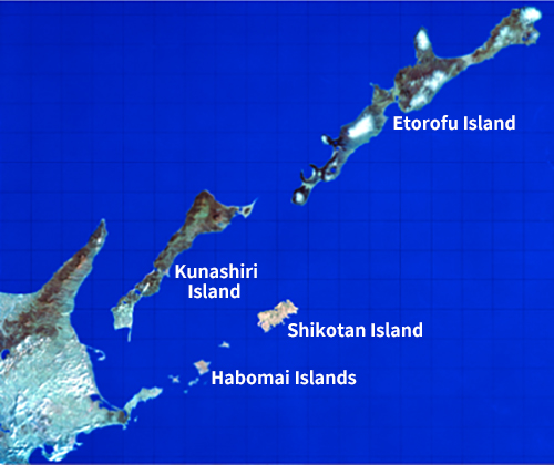
(Photo credit: TRIC/NASDA/EOSAT.1992)
History of the Northern Territories
Space-time Map Learn about the Northern Territories beyond space and time.
Click  on the map for details.
| year | location | title | content |
|---|---|---|---|
| Early 17th century | Uruppu Island | The Matsumae Domain trades Kurile sea otter fur. | According to the Matsumae Domain’s Shinra no Kiroku (Record of Shinra), Ainu people in the Menashi region (Hokkaido’s Nemuro region) come to Matsumae to trade on nearly 100 boats loaded with eagle feathers and sea otter fur from around 1615 to 1621. No sea otters are caught on the main island of Hokkaido. Rakko Island (“sea otter island”) is known as a production area, as shown in missionary records. |
| 1635 | Hokkaido | Murakami Kamonzaemon creates a Map of Ezo after touring the islands. | In the Matsumae Domain, Murakami Kamonzaemon conducts a survey of the islands along the coast of Ezochi and creates a map. The map will be lost, but the domain map that is submitted to the shogunate in 1645 (Shoho 1) is believed today to have been based on that map. |
| 1643 | Uruppu Island | Captain Vries land on Uruppu Island. | Captain Maerten Gerritsz de Vries, who has been dispatched by a stadtholder of the Netherlands stationed in Jakarta, Indonesia, lands on Uruppu Island. The location of the Kurile Islands is first introduced to Europe from Captain Vries’ logbook and map. However, Uruppu Island is mistaken for part of the Americas, and Kunashiri Island is erroneously drawn as being connected to Hokkaido. |
| 1644 | four northern islands | The Northern Territories are marked on the Shoho Map of Japan. | The shogunate orders all domains in the country to submit their maps, in order to create the Shoho Map of Japan. The map submitted by the Matsumae Domain shows island names from which present islands can be inferred, such as “Kunashiri,” “Etohoro” and “Urufu.” This map is thought today to be based on a map created in 1635 (Kanei 12), and it can be seen that the existence of the Northern Territories and the names of the islands are already known. |
| 1711 | Shumushu Island | Russia explores the Kurile Islands for the first time. | Two Cossack rebels, including I. Kozyrevsky, land on Shumushu Island in the Kuriles and conquer it by fighting the islanders. They conquer Paramushiru Island the following year. They stage an assault on Onnekotan Island in 1713 and survey these islands before returning home. |
| 1715 | four northern islands | The Matsumae Domain reports its rule over the Kurile Islands to the Shogunate. | The Matsumae Domain submits a report on geography and customs to the shogunate, saying, “The main island of Hokkaido, the Kurile Islands, Kamchatka, and Karafuto are governed by the Matsumae Domain. The Ainu live in these areas, each of which is led by a chief, but the Matsumae Domain has overall control.” |
| 1738 | our northern islands, Shikotan Island | The Spangberg Expedition reaches Japan. | In 1738 and 1739, the Russian naval officer Martin Spangberg advances southward through the Kurile Islands in search of a sea route to Japan and arrives on the coast of Japan. His group drafts a map in dense fog. The information on the islands on the map is inaccurate due to the dense fog, but the first observation is made of the Kurile Islands consisting of a number of islands, a fact that is reported in Western Europe. |
| 1754 | Kunashiri Island | A basho (trading post) opens on Kunashiri Island. | The Matsumae Domain was initially trading mainly with Akkeshi, but it expands its trading area to Kiritappu and Nemuro’s Notsukamappu. The Matsumae Domain opens a <i>basho</i> (trading post) on Kunashiri Island and also goes to the islands of Etorofu and Uruppu for trade. |
| 1783 | Edo | The book Akaezo Fusetsuko warns of Russia’s southward expansion. | In Japan, there is growing concern about the northern area due to Russia’s southward advancement to the Kurile Islands. The concern is initiated by the book Akaezo Fusetsuko, written by the physician Kudo Heisuke of the Sendai Domain. This book on Russia influences the shogunate in terms of raising awareness of the need to take measures against Russia and to develop Ezochi. |
| 1785 | Etorofu Island | Mogami Tokunai surveys the Northern Territories. | After reading Akaezo Fusetsuko, Tanuma Okitsugu, a senior counselor to the shogun, dispatches the first expedition to Ezochi. Mogami Tokunai and others join the expedition, and Tokunai later writes Ezo Soshi, a report on how they went from Kunashiri Island to Etorofu Island to carefully survey the situation of Russia’s southward expansion and landed on Uruppu Island also to observe the situation of the islands north of Uruppu Island. |
| 1792 | Nemuro | Arriving in a "northern black ship," Adam Laxman seeks trade with Japan. | Bringing Daikokuya Kodayu and two other Japanese men who have drifted to Kamchatka, Adam Laxman, a Russian under orders from Catherine II, enters the port at Nemuro with a letter from the Russian Empress seeking trade. The shogunate is grateful for the repatriation of the stranded sailors but refuses trading. Russia’s southward expansion, in the form of “northern black ships,” shocks the shogunate, eventually leading to the shogunate's direct control of Ezochi. |
| 1798 | Etorofu Island | Kondo Juzo erects a station pole indicating Japanese territory on Etorofu Island. | The shogunate dispatches a large-scale patrol of more than 180 people to Ezochi in April. At this time, a team headed by Kondo Juzo, who is a shihai kanjo (managing accountant), surveys Kunashiri and Etorofu with Mogami Tokunai and others, and erects on Etorofu Island a national station pole inscribed with the words “Japan’s Etorofu.” |
| 1800 | Etorofu Island | Takadaya Kahei begins to develop Etorofu Island. | In 1799 (Kansei 11), the shogunate takes eastern Ezochi from the Matsumae Domain and puts it under its own direct control. The following year, Kondo Juzo crosses over to Kunashiri and Etorofu again with Takadaya Kahei and others, establishes a “village system” that incorporates the administrative system of the mainland, and opens fishing grounds and water routes to the islands. It is around this time that Takadaya Kahei takes his own ship, Shinetsumaru, to open a route between the islands of Kunashiri and Etorofu, and opens 17 fishing grounds on Etorofu Island. |
| 1801 | Etorofu Island, Kunashiri Island | Soldiers of the Nambu Domain head north to provide defense. | The shogunate sets up guard stations on the islands south of Etorofu Island. At first, more than 100 soldiers each from the Nambu and Tsugaru domains guard the islands. The Sendai Domain also joins the defenses of Etorofu and Kunashiri islands from 1808 (Bunka 5) onward. |
| 1807 | Etorofu Island | Nikolai Rezanov's men attack Etorofu Island. | Seeking trade with Japan, Nikolai Rezanov, an envoy of the Russian Emperor Alexander I, arrives in Nagasaki in 1804 (Bunka 1), relying on a promise between the shogunate and Laxman. As the shogunate rejects this, however, Rezanov orders his subordinate Nikolai Khvostov and others to take retaliatory measures, and they attack Karafuto in 1806 (Bunka 3) and Etorofu Island in the following year, assaulting Japanese subjects and setting fire to Japanese ships. |
| 1811 | Kunashiri Island | The Golovnin Incident occurs. | In 1811 (Bunka 8), Major Golovnin, the commander of the Russian frigate Diana, and others explore the west coast of Karafuto and survey the Kurile Islands. When they land on Kunashiri Island’s Tomari, they are caught by guards from the Nambu Domain, sent to Matsumae and confined. Seeking the return of Golovnin, Vice Commander Rikord captures Takadaya Kahei, a boatman of the shogunate. Takadaya Kahei tries to resolve the conflict between Japan and Russia and achieves a peaceful arrangement. Thanks to his great efforts, Golovnin and Takadaya Kahei are released and exchanged. |
| 1855 | The border between Japan and Russia is demarcated. | In 1853 (Kaei 6), the Russian Emperor Nicholas I dispatches Admiral Putyatin to petition the shogunate for trade and offers to demarcate the border between Karafuto and the Kuriles. After several unsuccessful rounds, the negotiations are moved to Shimoda (Shizuoka Prefecture) in 1855 (Ansei 1), where they continue. The Treaty of Commerce, Navigation and Delimitation between Japan and Russia is signed, and the border between Russia and Japan is demarcated. Under the treaty, the border between the two countries is drawn between the islands of Etorofu and Uruppu, and it is decided that the islands south of Etorofu are to be incorporated into Japanese territory and the islands north of Uruppu are to belong to Russia. However, no agreement is reached on Karafuto, which remains an area inhabited by a mix of two peoples with undetermined borders. | |
| 1875 | Kurile Islands | The Treaty for the Exchange of Sakhalin for the Kurile Islands is concluded, incorporating all the Kurile Islands into Japanese territory. | The Meiji government dispatches Enomoto Takeaki as a special envoy to Russia in 1874 (Meiji 7) and concludes the Treaty for the Exchange of Sakhalin for the Kurile Islands with the Russian Foreign Minister Gorchakov on May 7, 1875 (Meiji 8). Pursuant to this treaty, Sakhalin Island, which has been considered an area inhabited by a mix of two peoples under the Treaty of Commerce, Navigation and Delimitation between Japan and Russia, becomes Russian territory, and the Kurile Islands (18 islands from Uruppu to Shumushu) become Japanese territory. |
| 1893 | Shumushu Island | Gunji Shigetada explores the Northern Kurile Islands. | Gunji Shigetada establishes Chishima Hokogikai (a development business association) in order to protect the Kurile Islands from foreign countries and to promote the development of the islands. He has its members land on the islands of Shumushu, Shasukotan and Paramushiru and spend the winter there. However, all the members on Shasukotan and Paramushiru die of illness, attesting to the harsh nature of the northern Kurile Islands and the difficulty of their development. His endeavor ends in failure when most of the members withdraw after the Russo-Japanese War begins in 1904 (Meiji 37). |
| 1923 | four northern islands | The "municipal system" is enforced on Etorofu Island and south. | The Kurile Islands north of Uruppu Island consist of the three counties of Uruppu, Shimushiru and Shumushu, which are under the direct control of Nemuro Subprefecture. The municipal system is not implemented there, but is implemented in the area south of Etorofu Island in April 1923 (Taisho 12). One county (Kunashiri) and two villages (Tomari and Ruyobetsu) are established on Kunashiri Island, with three counties (Etorofu, Shana and Shibetoro) and three villages (Rubetsu, Shana and Shibetoro) on Etorofu Island, and one country (Shikotan) and one village (Shikotan) on Shikotan Island. The municipal system is implemented in April 1915 (Taisho 4) on the Habomai Islands, which belong to the administrative area of Habomai Village, Hanasaki County. |
| 1943 | Cairo | The Cairo Declaration settles postwar territorial issues. | The Cairo Declaration on military operations against Japan is issued by leaders of the US, the UK and China, stating that Japanese shall be deported from the Pacific Islands, Manchuria, Taiwan and Hoko Island, Korea (which Japan obtained in the First World War), and all other areas that Japan "has taken by violence and greed.” The Kurile Islands have been possessed by Japan peacefully under the Treaty for the Exchange of Sakhalin for the Kurile Islands, and the four northern islands are inherent parts of Japanese territory that had never been held by a foreign power. It is clear that they are not areas “Japan captured.” |
| 1945 | Yalta | The Yalta Agreement, a secret pact among the US, UK and Soviet Union is made. | The Yalta Agreement is concluded by the US, UK and Soviet Union. The agreement stipulates that the Kurile Islands shall be “handed over” to the Soviet Union, but it merely states a postwar policy among the leaders of the Allies. Japan is not to be bound by the agreement, as it has not participated in the agreement. In any event, the agreement is contrary to the Cairo Declaration of “no territorial expansion,” and the US government also denies any legal effect of the agreement in its official opinion on the issue on September 7, 1956. |
| 1945 | four northern islands | Soviet troops occupy the Northern Territories. | Despite the Neutrality Pact between the Soviet Union and Japan, the Soviet Union declares war on Japan and launches an early dawn attack on August 9. Japan accepts the Potsdam Declaration and surrenders unconditionally on August 14, but Soviet troops begin invading the Kuriles and land on Etorofu Island on August 28. They reach the islands of Kunashiri and Shikotan on September 1 and the Habomai Islands on September 3, occupying all the islands by September 5. |
| 1945 | Nemuro | The Movement for the Return of the Northern Territories begins, with the First Petition. | Mayor Ishisuke Ando of Nemuro and others petition General MacArthur, the Supreme Commander of the Allied Powers, on December 1, demanding the return of the Northern Territories. This is the first petition to demand the return of these territories, and it marks the start of the irredentist movement. |
| 1947 | Sapporo | The Hokkaido Assembly resolves the Petition for the Return of the Northern Territories. | On July 22, in response to public opinion calling for the return of the Northern Territories, which constitute part of Hokkaido, the Hokkaido Assembly passes a resolution to petition General MacArthur for the return of the Habomai Islands, Etorofu Island and Kunashiri Island. This becomes the first resolution ever to be passed by all prefectural and municipal assemblies nationwide. |
| 1951 | San Francisco | The San Francisco Peace Treaty is concluded. | The San Francisco Peace Treaty (a peace treaty involving Japan) is concluded between Japan and 48 countries other than the Soviet Union. The treaty stipulates that Japan shall renounce all rights, titles and claims over the Kurile Islands, part of Sakhalin, and its neighboring islands. Prime Minister Yoshida mentions not only that the Habomai Islands and Shikotan Island constitute an integral part of Japan but also that both Kunashiri and Etorofu have long been parts of Japanese territory, drawing the attention of the participants at this meeting to these facts. The United States, which has drafted the treaty, also clearly acknowledges the attribution of the four northern islands to Japan in the 1956 State Department Memorandum of Understanding. |
| 1956 | Moscow | Japan–Soviet relations are restored. | The Japan–Soviet Joint Declaration is signed, restoring diplomatic relations between Japan and the Soviet Union. During the negotiations, Japan has demanded the return of the four northern islands, a position supported by the United States. However, no agreements have been reached, and negotiations to conclude a peace treaty, including the resolution of the territorial dispute, are to be continued once diplomatic relations have been restored. The joint declaration stipulates that the Habomai Islands and Shikotan Island shall be handed over to Japan after the conclusion of a peace treaty. |
| 1980 | Nemuro | The symbolic “Bridge to the Four Islands” is completed. | A symbolic statue named the Bridge to the Four Islands is completed in Bokyo no Misaki Park at Cape Nosappu in Nemuro. The statue, measuring 35 meters in bottom length and 13 meters in height, is created to mobilize the strong desires and prayers of the public seeking the return of the Northern Territories and to symbolize their determination to earnestly continue the irredentist movement until those territories are returned. The four northern islands are represented by four blocks, which are connected to form a large bridge, and the statue represents as a gate for prayers on the return of the Northern Territories. |
Looking at the history of the Northern Territories, from the northern exploration by the Edo shogunate to the treaty negotiations with Russia and the invasion and illegal occupation by the Soviet Union, it is clear that the four northern islands are Japanese territory. After the war, a movement for the return of these islands, which began with the wishes of former islanders, spread widely as the ardent wish of the Japanese people.
The Northern Territories described by former islanders: memories and historical testimonies
The 17,291 islanders who once lived on the four northern islands were expelled in the Soviet invasion. A history of hardship remains in the memories of the islanders, and their testimonies allow us to know the true history.
Go to historical testimonies page
Digest version of former islanders’ experiences
This is a digest version of interviews with former residents of the four northern islands.
- Interview details
-
- Island memories
- Soviet occupation
- Escape
- Life under occupation
- Repatriation
- Thoughts for the island

Mr. Chuhei Yamamoto, Shibetoro Village, Etorofu Island
Born in 1935 (age 10 at the end of the war)
- Interview details
-
- Repatriation

Mr. Yoichi Mikami, Rubetsu Village, Etorofu Island
Born in 1937 (age 8 at the end of the war)
- Interview details
-
- Soviet occupation
- Repatriation

Mr. Shohei Yamamoto, Shibetoro Village, Etorofu Island
Born in 1928 (age 17 at the end of the war)
- Interview details
-
- Soviet occupation
- Repatriation in 1947