An Overview of the Northern Territories
1. Northern Territories
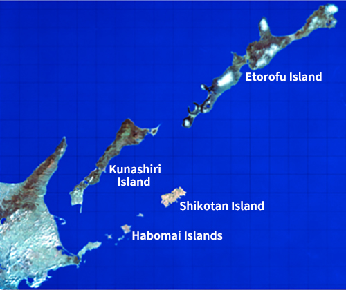
The four northern islands east of Hokkaido (Habomai, Shikotan, Kunashiri and Etorofu) remain occupied by Russia without legal grounds. “The Northern Territories” refers to these four northern islands, which are part of Japanese territory.
(Photo credit: TRIC/NASDA/EOSAT.1992)
2. Islands of the Northern Territories
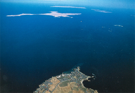
(1) Habomai Islands
This archipelago, which covers 95 km 2 , consists of islands scattered 3.7 km off Cape Nosappu, which is on the Nemuro Peninsula of Hokkaido, and northeastward, including Kaigara, Suisho, Akiyuri, Yuri, Shibotsu and Taraku. The islands feature rolling hills covered with bamboo grass, and there are few trees. In the past, the islands were home to many Japanese, but now no one lives there. Only Russian guards are stationed. The surrounding area is known as a rich fishing ground.
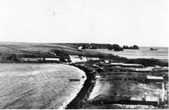
(2) Shikotan Island
This 251-km2 island is 22 km northeast of the Habomai Islands. Known for its natural splendor, the island features verdant hills. Alpine plants spread throughout the area. It used to be an affluent island, with a whaling station and natural harbors.
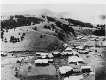
(3) Kunashiri Island
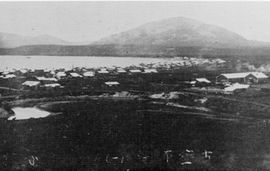
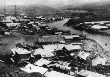
Located 16 km offshore and northeast of Hokkaido, between Hokkaido’s Nemuro and Shiretoko peninsulas, this is the second-largest island (1,490 m 2 ) in Japan (excluding Japan’s major islands). This volcanic island, which is blessed with hot springs and scenic spots, was home to some 7,400 Japanese at the end of the war. In the northeast is Mt. Chacha, which is the highest peak of the four islands and is known as one of the most beautiful double volcanoes in the world.
(4) Etorofu Island
This is the largest island in Japan (3,168 km2) other than the four major islands, and it marks the northernmost point in Japan (45°33'N). Like Kunashiri Island, it is a volcanic island, with 1,000- to 1,500-meter-high volcanoes. Before the war, the area flourished in fishery and was home to salmon and trout hatcheries, canning factories and whale processing plants. The area is also known for mining and forestry.
3. Nature in the Northern Territories
Facing the Pacific Ocean to the east and the Sea of Okhotsk to the west, the islands are in a sea area where warm and cold currents flow. As a result, sea fog rises in summer, but due to the marine climate, the winters are less severe than those of inland Hokkaido. Despite the many windy days throughout the year, there is scant snowfall.
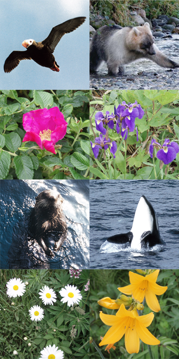
The distribution of flora and fauna in the Northern Territories is exactly the same as that of the main island of Hokkaido, but is different from that of the Kurile Islands north of Uruppu Island.
Dr. Kingo Miyabe (1860 – 1951), a professor emeritus of Hokkaido University, established the Etorofu Strait between the islands of Etorofu and Uruppu as a plant distribution boundary. Called the “Miyabe Line,” it is known as a biological distribution boundary of Hokkaido, along with the Hatta Line (Soya Strait) and the Blakiston Line (Tsugaru Strait). The Northern Territories are found amidst rich fishing grounds and are a treasure trove of flora and fauna. Located at the southern limit of drift ice in the Sea of Okhotsk, as is the Shiretoko World Natural Heritage site, it is said to have the greatest biodiversity of anywhere in the world. Various species of whales, including killer whales, hunt the abundant fish here. Brown bears, which feed on migrating salmon, and Blakiston’s fish owls also live here. The white-colored brown bears that inhabit Kunashiri and Etorofu are found nowhere else in the world.
Although the Northern Territories have a natural ecosystem that is rare for any place in the world, it is feared that the ecosystem here has been damaged in recent years by large-scale Russian development activities.
4. The Northern Territories by Numbers
(1) Area comparison between the Northern Territories and other Japanese islands
The Northern Territories measure approximately 5,000 km2, about the size of Chiba Prefecture, and account for roughly 1.3% of the Japan’s land area (378,000 km2). These territories are occupied by Russia without legal grounds.
- Habomai Islands
- 95㎢


- Ogasawara Islands
- 104㎢
- Shikotan Island
- 251㎢


- Oki Islands (Dogo)
- 243㎢
- Kunashiri Island
- 1490㎢


- Main island of Okinawa
- 1217㎢
- Etorofu Island
- 3168㎢

- Tottori Prefecture
- 3507㎢
※Prefectural and Municipal Area Survey in 2021, Geospatial Information Authority. The area includes surrounding small islets, and the figures are rounded to the closest whole number.
(2) The Northern Territories in numbers
17,291 people
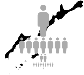
This was the population of the Northern Territories in 1945.
The main hall of the Yokohama Arena, a concert venue, accommodates 17,000 people.
3.7km
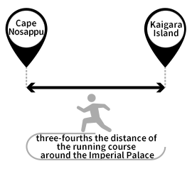
This is the shortest distance between the Northern Territories and the main island of Hokkaido (the distance between Cape Nosappu and Kaigara Island).
It is roughly three-fourths the distance of the running course around the Imperial Palace.
204km
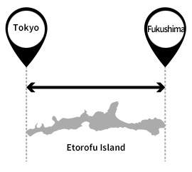
This is the length of Etorofu Island, the largest island in Japan other than the four main islands. It is roughly the distance between Sapporo and Obihiro (208 km), and similar to the distance between Tokyo and Fukushima Prefecture (200 km).
※The figures are based on information from the Yokohama Arena facility outline, the Chiyoda City Tourism Association, and the Hokkaido Tourism Organization.